


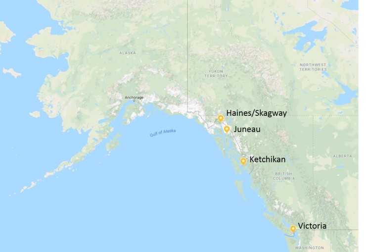
Trip overview: 10 day Inside Passage Alaskan cruise on the Grand Princess cruise ship. We left port from San Francisco and made stops at Ketchikan, Juneau, Haines, and Victoria. The ship also went on a scenic cruise through the Tracy Arm Fjord. Highlights include steep fjords, glaciers, whale watching, Alaskan Wilderness, and the food and entertain aboard the Grand Princess. We went on this cruise in June of 2018.

Shortcuts to various sections of this article:
- Jump to San Francisco and days at sea
- Jump to Ketchikan
- Jump to Haines
- Jump to Juneau
- Jump to the Tracy Arm Fjord
- Jump to Victoria
- Jump to arrival at San Francisco
Shop Sale & Clearance Items at REI.com (up to 50% off)!
General Information:
Logistics: The Inside Passage Alaskan cruise with Princess can be booked to depart from either San Francisco, Seattle, or Los Angeles, or Vancouver. The round trip cruise takes 10 days from San Francisco, 12 days from Los Angeles, and 7 days from Seattle or Vancouver. We left from San Francisco because we live nearby, but it also has the added benefit of the cruise ship sailing under the Golden Gate Bridge when you leave port. This makes for a dramatic start to the cruise (along with the great views of the San Francisco skyline and Alcatraz).
On the morning of your cruise, you’ll want to give yourself plenty of time to arrive to port before the last call for passengers. Traffic can be pretty slow when 1,000 passengers are all trying to drive to the port. When you arrive, you leave your luggage with the cruise line employees and then enter the port security area. Your checked luggage gets x-ray scanned and then taken to your room on the ship by the cruise employees. On your way through security, your passport is checked, you go through a metal detector, and your carry-on gets x-rayed. After that, you head to the Princess check-in area and receive your cruise card (used for all purchased on board) and information about the ship. Once you have your cruise card, you are allowed to board the ship and start having fun. Most people head straight to the buffet for lunch or to the bar for a drink. In the afternoon before the ship starts to sail, there is a safety meeting that everyone must attend. After the meeting, the ship sails out of the San Francisco Bay and passes under the Golden Gate Bridge on the way to Alaska.
Supplies: The weather can be a little unpredictable with Alaskan cruises, so it is best to pack clothes that allow you to be flexible. There was a heat wave in Alaska the week we cruised, so it was roughly 80 degrees each day we disembarked. However, while at sea, the temperature on the top deck was quite chilly and windy. And, during the scenic cruise in the Tracy Arm Fjord it was downright cold. The best plan is to bring several different layers that can be mixed and matched to the different conditions. A definitely not exhaustive list of items to bring is:
- Thin, light insulated jacket (North Face Thermoball Jacket)
- Light rain jacket/shell (North Face Venture 2 Jacket)
- Hiking or walking shoes
- Warm long sleeve shirt (Pendleton Wool Board Shirt)
- Comfortable hiking/travel pants (prAna Zion pants)
- Long sleeve active shirt for sun protection (Columbia Featherweight Shirt)
- Comfortable socks for lots of walking (Merino wool crew socks)
- Lightweight gloves for on deck (Smartwool liner gloves)
- Warm beanie hat (Smartwool merino beanie)
- Swim suit for pools and hot tubs
- Workout clothes for the gym
- Outfit for dinner on formal nights
Beyond clothes, you’ll want to pack anything that you believe will be expensive or hard to buy once you are on the boat. This may include:
- Small-to-medium sized (Osprey Talon 22 Pack)
- Compact binoculars (Nikon Travelite Binoculars)
- Polarized sun glasses
- Rum runners (for sneaking alcohol on the boat in your checked luggage)
- Sunscreen
- Playing cards and other games
- A refillable water bottle or nalgene
- Bonine to prevent motion sickness
- Bug repellent (depending on your excursions)
Excursions: It is best to book excursions early on, either before boarding the ship or during the first day or two of the trip. After a couple days on board, many of the best excursions sell out and it can be difficult to research alternative options while at sea due to the limited ability to make phone calls and shop around online. Doing the bulk of your research before the cruise starts is probably the best bet to find the most exciting and inexpensive excursions. Doing research beforehand allows you to look at tripadvisor and check reviews and even allows you to book excursions directly through the local operators (to save a bit of money). The only downside of booking directly with tour operators is that you are solely responsible for getting off the ship and meeting up with your tour operator. This is not really difficult, but is just something you need to coordinate. If you book excursions through Princess, you pay a bit more, but they tell you exactly when you need to get off the boat and where you need to go.
The excursions vary anywhere from $50 guided hikes to $250 float plane rides to expensive glacier tours and fishing trips >$500. Many of the cheaper excursions can be easily skipped and done on your own if you research ahead of time. We did one of the hikes on our own and it was easy to find and follow the trail. You can also rent a car and drive yourself to many attractions if you wish to avoid a sightseeing tour with a shared bus. We rented a car in Juneau and it was pretty easy. Other tours are impossible to do on your own (plane rides, fishing, rafting, etc.), so booking the excursion is your only bet!
………..
Days 1-3: Depart San Francisco, then at sea two days
The first day on the boat starts with a nice cruise through the San Francisco Bay as the ship leaves the dock. You get great views of the San Francisco skyline and pass by landmarks like Angel Island and Alcatraz. Then, the cruise ship passes under the Golden Gate Bridge and heads out to the open water. You will want to be on the top deck of the ship for the sail away so you get the best unobstructed views.
After the ship heads under the bridge you have nice views for a little while longer, but soon you are just sailing in open water. During our cruise, the water was quite rough during our first few days at sea. I highly suggest taking Bonine each morning until you are used to the rocking and swaying. For the days at sea before reaching Ketchikan, we spent much of our time exploring indoors the boat. It was super cold and windy on the top deck, so these days provided a good opportunity to get acquainted with the different bars, restaurants, and amenities. Once we got to the Inside Passage, the water calmed down and the sailing was much more smooth.
On the Grand Princess there are several attractions. There are multiple pools and hot tubs. You can not really swim for a workout because the pools are small, but the hot tubs provides some very nice views off the back of the boat. Other amenities include shuffle board courts (outdoors on top deck), a large outdoor movie screen, a small putting green, a basketball hoop, a gym with open equipment and some fitness class, and a casino. For food there are a few main dining rooms where you get table service, there is a self-serve buffet, there is a pizza place and a grill (burgers and sausages), and there are some specialty restaurants that serve nicer dinners for an extra charge. For evening entertainment there are several bars and stages that have music or shows every night. Overall, there is plenty to do on the ship and you get eat at a variety of restaurants if you get bored of the food at the main dining room.


………..
Day 4: Port of call #1, Ketchikan, Alaska
After a few rough days at sea, the Grand Princess arrived in Ketchikan, Alaska on the morning of the 4th day. Ketchikan was the first port of call on this itinerary. For this stop we had booked a float plane excursion to fly over Misty Fjord National Monument. We booked our trip independently from Princess and when straight through the operator. Disembarking from the ship took quite long this morning because our ship was not docked. Instead of just walking off the ship everyone had to take a short ride in a tender in order to reach shore. It is always good to check with a Princess employee the night before disembarking to make sure you understand the disembarkation process for the next morning. For the tenders, you meet in one of the dining rooms and receive a number. You wait for your number to be called and then board the tender and head to shore.
We did not want to miss our excursion, so we grabbed an early tender and got to Ketchikan around 8:15am. This gave us ~1.5 hours to explore Ketchikan before the start of our plane ride excursion. This was plenty of time for us to see most of the small downtown. The town is cute, but is largely just full of shops for tourists. There is a lumberjack show (tickets are ~$40 per adult) in town that seemed quite popular. We didn’t have time to see a show though.
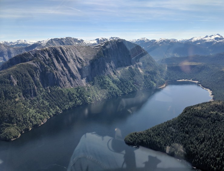
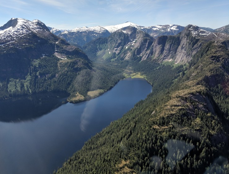
We decided to do the Misty Fjord Sea Plane excursion in Ketchikan because it seemed like a great way to view a large amount of the wilderness. The excursion was great and the fjords were really impressive. Other popular excursions for this port of call seem to be wildlife cruises, kayaking, and zip-lining.


Float Plane tour of the Misty Fjord National Monument

Map of the greater area around Ketchikan. The green colored area is Misty Fjord National Monument. The purple colored area is Tongas National Forest.

For the excursion, we met up with the operator at a landmark downtown. We then took a shuttle ride to the dock/hanger, paid our bill, and got ready to take off.


After the excursion we explored town a bit longer. We ended up grabbing another drink at Sourdough Bar downtown. This is a nice little dive bar that has shuffle board and pool. After about 45 minutes there, we were hungry and wanted to head back to the ship for lunch.
We headed to the dock to board one of the tenders and quickly realized there was a massive line of people waiting to catch a tender. After about an hour wait in line standing in the sun, we were able to get back on the ship. The wait was so long that the Grand Princess captain gave all passengers a drink ticket to help alleviate some of the complaints. I believe this is not the typical situation, but be aware that there can be issues if need to take a tender back to the ship.

………..
Day 5: Port of Call #2, Haines, Alaska
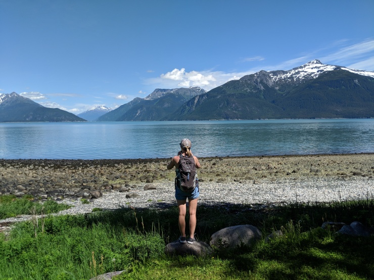
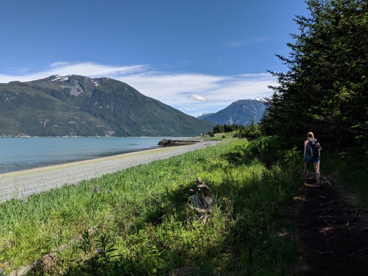
On the morning of the 5th day, the Grand Princess was docked in beautiful Haines, Alaska. Haines is a small town that is surrounded by mountains. The attractions in the area include hiking, boating and fishing on the Chilkoot Lake, rafting on the Chilkat River, and eagle viewing. We chose not to book an excursion at this port of call and instead did a hike on our own. Disembarking the boat was easy on this day because the boat was docked and no tenders were required.


Haines hiking: Battery Point Trail – 8 miles +/- 1,400 feet of elevation
After disembarking, we started off on the Battery Point Trail hike. This is an 8 mile round trip hike that provides some great views of the mountains surrounding the Chilkoot Inlet. The trail starts with a ~2.3 mile walk down Beach Road. At that point you begin a ~1.7 mile hike along the trail that leads to Battery Point. After reaching the point, you simply hike back the way you came. Overall the hike is not too difficult. If you wanted to skip the walk along the road, you could try to hire a ride to the trailhead. The trail is pretty easy to follow. The only tricky point is near Battery Point. Here the trail splits into several small trails. If you pay attention and keep going in the same general direction, you eventually will reach Battery Point and then can easily find your way back.


When we reached the port we started the hike from, we decided to walk to downtown Haines and grab some food. We ended up getting burgers at the Bamboo Room and Bar, which was pretty good. There are a handful of restaurants downtown and there is a small brewery. After the late lunch, we walked back to the port and boarded the Grand Princess again.


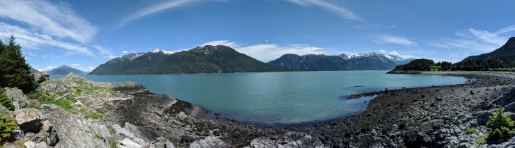
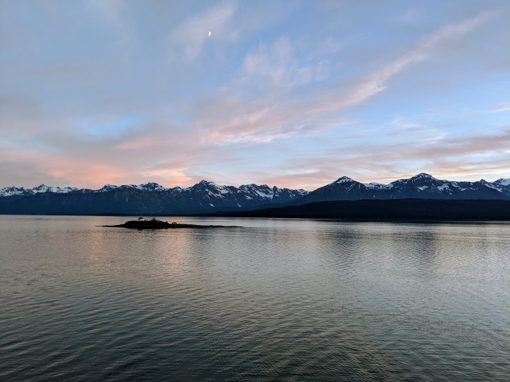
After all the passengers boarded the ship, it set off again and headed towards Juneau, Alaska. The views in the evening were really great and we saw several whales jumping in the water. The ship travels through the Favorite Channel and you have mountain views on both sides of the ship. The sunset seemed like it lasted for multiple hours, which made the experience great.


………..
Day 6: Port of Call #3, Juneau, Alaska
On Day 6, you wake up in port at Juneau, Alaska. The view from port is not as scenic as that at Haines, but the view is still nice. While in Juneau we rented a car because the sights we wanted to see were fairly spread out. The place to pick up the car was within walking distance of the port, so it was easy to grab the car and go in the morning.


After picking up the car, we drove to the Mendenhall Glacier Visitor Center (about 25 minutes from port) and did a short hike. We then drove to Eagle Beach (about 45 minutes from port). If you do not want to rent a car, there are plenty of excursions or other things to do in town in Juneau. Some popular things to do include the Mount Roberts Tramway, wildlife watching tours, floating or kayaking in the Mendenhall River, hiking or sledding on the Mendenhall Glacier, or taking a plane or helicopter ride.
Mendenhall Glacier Hiking: Nugget Falls and Photo Point – 2.9 miles +/- 360 feet elevation
There are several trails you can hike near the Mendenhall Visitor Center. We chose to hike the Nugget Falls and Picture Point Trails because they provide good views of the Glacier and of Nugget Falls within a low mileage hike. The total round trip mileage to hike both trails was just about 3 miles.


Note: If you are more adventurous and want to actually hike to the base of the Mendenhall Glacier, you can drive to the West Glacier Trailhead. This trail follows along the northwest side of Mendenhall Lake for several miles. Near the end, you can scramble all the way to the base of the Mendenhall Glacier. If conditions allow, you can then hike on the glacier and/or explore the ice caves at the base (be very careful of course).
This trailhead is not accessible from the Mendenhall Glacier Visitor Center. You must drive over towards Mendenhall Campground in order to access the trail. The trailhead can be found here. The trail is between 6-7 miles round trip. To get all the way to the base of the glacier, you must scramble off trail for the last mile or so. If you want to hike this trail, it is advisable to wear good hiking shoes, be reasonably fit, and be comfortable with unmaintained trail sections.
If you hike the West Glacier Trail to the endpoint, you will be some see some amazing views of the Mendenhall Glacier. More info about the trail can be found on the USFS website.


Eagle Beach Hike – 1.5 miles +/- 20 feet elevation
After finishing up at the Mendenhall Glacier Visitor Center, we drove towards Eagle Beach. This beach is very scenic and is a great habitat for birds. We saw several Eagles out on the beach. Along the drive we stopped for lunch at the Sand Bar and Grill. It had some of the best fish and chips we have ever had. It’s definitely a local dive bar type of place, but the food was great. After lunch, we drove to Eagle Beach and then hiked out to the waters edge. Tide was low, so we were able to hike out about 0.75 miles. This beach is a nice place to relax and enjoy the scenery and wildlife.


After the beach, we drove back to Juneau. We walked around the city for a bit. We did not enjoy the city too much as it seemed a little dingy and had a lot of pretty gross bars and drunk characters. So, we wrapped things up and headed back to the Grand Princess.
………..
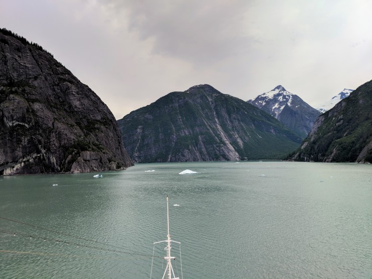
Day 7: Scenic cruise in the Tracy Arm Fjord, Alaska
The morning of the 7th day, we woke up early in order to see the great views as our ship cruised through the scenic Tracy Arm Fjord. We were up on the top deck by ~6:15am. This is the day you will want all your warm clothes on. It was quite cold at the front of the ship in the early morning. However, the views were great and it is worthwhile to wake up early and brave the cold.
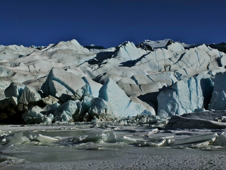
Our ship slowly cruised through the fjord before reaching an icefield in front of the Sawyer Glacier. The captain announced that we could not get any closer to the glacier that day because there was too much ice in the water. It’s not entirely clear if this was just bad luck or if the large cruise ships never actually go beyond this point. Either way, you could make out the glacier in the distance, but were not able to get a great up close view of the face of the Sawyer Glacier. The area is still very beautiful nonetheless. The captain then turned the boat around and cruised back through the Tracy Arm.
Once we made it out of the fjord, we headed through the Inside Passage on the way to Victoria, British Columbia. You will want to really soak in the views on this morning because these are the last great views of Alaska that you will see.


Then, the ship continues out to the Holkham Bay

………..
Day 8-9: At Sea and Victoria, British Columbia
After another full day at sea, you wake up on the 9th day in port at Victoria, British Columbia. Victoria is a pretty city that is easy to walk around and explore. We chose not to do any excursions here and simply walked around. Popular excursions are mostly bus tours to the famous Butchart Gardens, pub tours, or whale watching tours. We first walked to the downtown area and meandered for a bit. After that, we walked to Beacon Hill Park, which was a really nice area. When we were done exploring the park we headed to Heron Rock Bistro to grab some delicious poutine and have a beer.


We had thought about doing a more ambitious itinerary in Victoria, but we did not have much time at port. Going to Butchart Gardens would have been nice, but it is a ~40 minute drive each way to get there. Long story short, you will need to prioritize what you want to see in Victoria because it is hard to fit everything in.
………..
Day 10-11: At Sea and arrival at San Francisco
After another full day at sea, we arrived at port in San Francisco in the morning. Everyone gets assigned a time/group to disembark off the boat. Be sure to bring your cruise card with you when you disembark. The Princess crew will scan your card when you leave to make sure you get off the boat.

Thank you very much for a terrific journal and great photos of your trip! I’m now officially excited about the cruise in 3 weeks!! Bobbie Wallingford, Houston, TX
LikeLike
A fantastic report! We were on the same cruise and loved every minute of it – especially the weather. What great memories you have preserved.
I agree with you about Tracy Arm. We have been there five times, but only reached the glacier once. While it is good, it pales in comparison to Glacier Bay or Hubbard.
LikeLike
Thank you for sharing! We’re taking this cruise in June 2019. Just a little worried about over-packing since we’re flying into San Francisco from Atlanta, but I guess it’s better to be over prepared than under.
LikeLike
I hope you have a great cruise! Yes, packing for the Alaskan cruise is challenging given the weather can be anything from frigid to hot. How much cold weather clothing your bring will depend a bit on your interests. If you like to see all the scenery and stay on top of the boat deck, I would bring several warm layers. If you are more included to stay below deck during much of sailing, maybe you don’t need as many layers. For the excursions, it’s hard to say. We had really warm weather at our ports, so shorts and light jackets were all we needed. I could also see it being really cold on some of the glacier type excursions though! It’s a packing challenge, but is a really great cruise experience.
LikeLike